Source: http://bigthink.com/ideas/21259
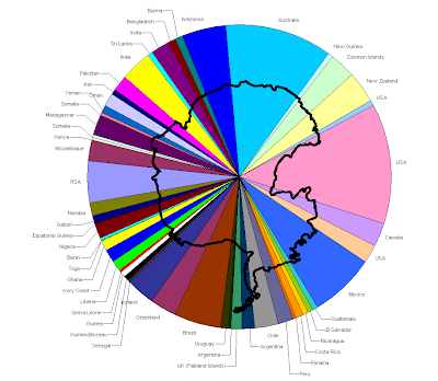
A pie chart is a type of geovisualization. This type of chart moved people away from recording data in like accountants in columns and rows and may have been the beginning of geovisualization or cartographic visualization. This is a hypothetical division of Antarctica based on an idea called the frontage principle. So, countries with an un-restricted southern passage across open seas to the continent can place a claim. The amount of frontage equals the claim size. Based on this Antarctica can be divided between 47 countries.
A pie chart is a type of geovisualization. This type of chart moved people away from recording data in like accountants in columns and rows and may have been the beginning of geovisualization or cartographic visualization. This is a hypothetical division of Antarctica based on an idea called the frontage principle. So, countries with an un-restricted southern passage across open seas to the continent can place a claim. The amount of frontage equals the claim size. Based on this Antarctica can be divided between 47 countries.
No comments:
Post a Comment